PDF Publication Title:
Text from PDF Page: 005
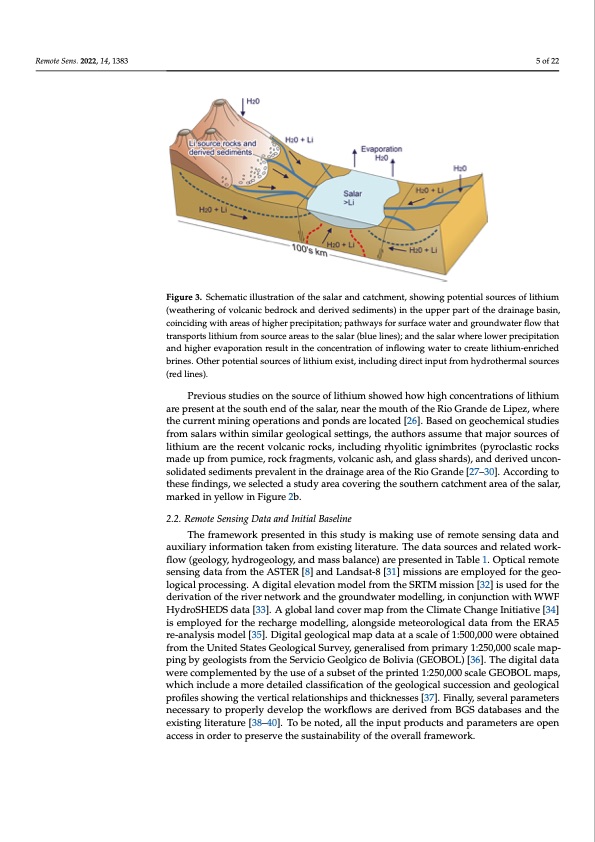
Remote Sens. 2022, 14, 1383 5 of 22 Remote Sens. 2022, 14, x FOR PEER REVIEW 5 of 21 Figure 3. Schematic illustration of the salar and catchment, showing potential sources of lithium Figure 3. Schematic illustration of the salar and catchment, showing potential sources of lithium (weathering of volcanic bedrock and derived sediments) in the upper part of the drainage basin, (weathering of volcanic bedrock and derived sediments) in the upper part of the drainage basin, coinciding with areas of higher precipitation; pathways for surface water and groundwater flow coinciding with areas of higher precipitation; pathways for surface water and groundwater flow that that transports lithium from source areas to the salar (blue lines); and the salar where lower precip- transports lithium from source areas to the salar (blue lines); and the salar where lower precipitation itation and higher evaporation result in the concentration of inflowing water to create lithium-en- and higher evaporation result in the concentration of inflowing water to create lithium-enriched riched brines. Other potential sources of lithium exist, including direct input from hydrothermal brines. Other potential sources of lithium exist, including direct input from hydrothermal sources sources (red lines). (red lines). Previous studies on the source of lithium showed how high concentrations of lithium Previous studies on the source of lithium showed how high concentrations of lithium are present at the south end of the salar, near the mouth of the Rio Grande de Lipez, where are present at the south end of the salar, near the mouth of the Rio Grande de Lipez, where the current mining operations and ponds are located [26]. Based on geochemical studies the current mining operations and ponds are located [26]. Based on geochemical studies from salars within similar geological settings, the authors assume that major sources of from salars within similar geological settings, the authors assume that major sources of lithium are the recent volcanic rocks, including rhyolitic ignimbrites (pyroclastic rocks lithium are the recent volcanic rocks, including rhyolitic ignimbrites (pyroclastic rocks made up from pumice, rock fragments, volcanic ash, and glass shards), and derived un- made up from pumice, rock fragments, volcanic ash, and glass shards), and derived uncon- consolidated sediments prevalent in the drainage area of the Rio Grande [27–30]. Accord- solidated sediments prevalent in the drainage area of the Rio Grande [27–30]. According to ing to these findings, we selected a study area covering the southern catchment area of these findings, we selected a study area covering the southern catchment area of the salar, the salar, marked in yellow in Figure 2b. marked in yellow in Figure 2b. 2.2. Remote Sensing Data and Initial Baseline 2.2. Remote Sensing Data and Initial Baseline The framework presented in this study is making use of remote sensing data and The framework presented in this study is making use of remote sensing data and auxiliary information taken from existing literature. The data sources and related work- auxiliary information taken from existing literature. The data sources and related work- flow (geology, hydrogeology, and mass balance) are presented in Table 1. Optical remote flow (geology, hydrogeology, and mass balance) are presented in Table 1. Optical remote sensing data from the ASTER [8] and Landsat-8 [31] missions are employed for the geo- sensing data from the ASTER [8] and Landsat-8 [31] missions are employed for the geo- logical processing. A digital elevation model from the SRTM mission [32] is used for the logical processing. A digital elevation model from the SRTM mission [32] is used for the derivation of the river network and the groundwater modelling, in conjunction with WWF derivation of the river network and the groundwater modelling, in conjunction with WWF HydroSHEDS data [33]. A global land cover map from the Climate Change Initiative [34] HydroSHEDS data [33]. A global land cover map from the Climate Change Initiative [34] is employed for the recharge modelling, alongside meteorological data from the ERA5 re- is employed for the recharge modelling, alongside meteorological data from the ERA5 analysis model [35]. Digital geological map data at a scale of 1:500 000 were obtained from re-analysis model [35]. Digital geological map data at a scale of 1:500,000 were obtained the United States Geological Survey, generalised from primary 1:250,000 scale mapping from the United States Geological Survey, generalised from primary 1:250,000 scale map- by geologists from the Servicio Geolgico de Bolivia (GEOBOL) [36]. The digital data were ping by geologists from the Servicio Geolgico de Bolivia (GEOBOL) [36]. The digital data wcoermepcloempelnetmedenbtyedthbeyustheeouf asesuofbsaestuobfstehteopfrtihnetepdri1n:2te5d0,010:205s0c,0a0le0GscEaOleBGOELOmBaOpLs,mwahpicsh, winhcilcuhdienaclumdoereadmetoarieledectalailsesdificlatsiosinficoafttihoengoefotlhoegigceaollsougciceaslssiounccaenssdiogneoalnodgigcaeloplorgoifcilaels psrhoofiwleisnsghtohweivnegrtihcealvreerltaictiaolnrsehlaitpiosnasnhdipthsiacnkdnetshsiecksn[3e7ss].eFsi[n3a7l]l.yF,isneavlelyr,aslepvaerraml peaterrasmnetceers- nseacreystsoarpyrotopeprrloypdeervlyeldopevtehleopwothrkefwloowrskflaroewdserairveedefriovmedBfGroSmdaBtaGbSasdeastanbdastehseaenxdistihneg elxitiesrtiantugrleit[e3r8a–tu40re]. [T3o8–b4e0]n. oTtoedb,ealnlottheedi,naplluthperiondpuuctsparondupcatsraamndeteprasrarmeeotperesnaarcecoespsenin aocrcdesesritnooprdeseerrtvoeptrheesesruvsetatihneabsuilsityaionfabthileitoyvoefrathlleforavmereawllofrakm.ework.PDF Image | Lithium Brine Deposit Formation
PDF Search Title:
Lithium Brine Deposit FormationOriginal File Name Searched:
remotesensing-14-01383-v2.pdfDIY PDF Search: Google It | Yahoo | Bing
Product and Development Focus for Infinity Turbine
ORC Waste Heat Turbine and ORC System Build Plans: All turbine plans are $10,000 each. This allows you to build a system and then consider licensing for production after you have completed and tested a unit.Redox Flow Battery Technology: With the advent of the new USA tax credits for producing and selling batteries ($35/kW) we are focussing on a simple flow battery using shipping containers as the modular electrolyte storage units with tax credits up to $140,000 per system. Our main focus is on the salt battery. This battery can be used for both thermal and electrical storage applications. We call it the Cogeneration Battery or Cogen Battery. One project is converting salt (brine) based water conditioners to simultaneously produce power. In addition, there are many opportunities to extract Lithium from brine (salt lakes, groundwater, and producer water).Salt water or brine are huge sources for lithium. Most of the worlds lithium is acquired from a brine source. It's even in seawater in a low concentration. Brine is also a byproduct of huge powerplants, which can now use that as an electrolyte and a huge flow battery (which allows storage at the source).We welcome any business and equipment inquiries, as well as licensing our turbines for manufacturing.| CONTACT TEL: 608-238-6001 Email: greg@infinityturbine.com | RSS | AMP |