PDF Publication Title:
Text from PDF Page: 010
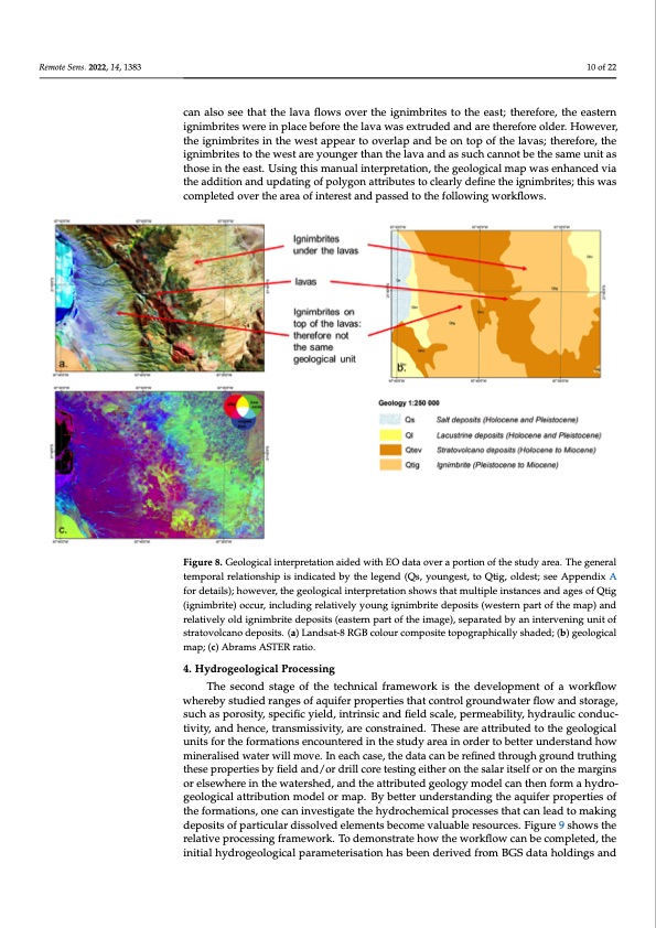
Remote Sens. 2022, 14, x FOR PEER REVIEW 10 of 21 Remote Sens. 2022, 14, 1383 clude two orange polygons representing the same ignimbrite deposit separated by a cen- Abrams ASTER ratio (as described in Section 2.2, Figure 8c) shows that the ignimbrites on to the east appear different in both composition and texture to those in the west. We can caalsnoasleseo tsheaet thaetlathvea lfalovwa sflovwesr othverigtnhiemibgrnitimesbtroittehseteoatsht;etheearset;fotrhe,rtehfeorea,stheerneiagsnteimrn- ibgrnitiemsbwrieteres wineprelaicnepbleafcoerbeetfhoerelatvhae lwavaas ewxatrsuedxetrduadned anredtahrerethfoerefolrdeeor.ldHeor.wHeovwere,vtehre, tihgenimgnbirmitebsritnesthine wtheestwaepspteaprptoeaorvteorloavpearnladpbaenodnbteoponofttohpeolafvtahse; ltahvearesf;otrhee,rtehfeorige,ntihme- ibgrnitiemsbtroitehsetwo tehsteawresytoaurnegyeorutnhgaenrttheanlavthaealnadvasansducahscsauncnhoctabnentohtebseatmhe suanmiteausnthitoasse tihnotsheeineathste. eUasitn.gUtshinisgmthainsumaalninutaelripnrtetraptiroenta,ttiohne,gtheoelgogeoiclaolgmicalpmwaapsweansheanhceadncveida vthiae tral brown polygon representing lava flows. Examination of the Landsat-8 image and the addition and updating of polygon attributes to clearly define the ignimbrites; this was addition and updating of polygon attributes to clearly define the ignimbrites; this was completed over the area of interest and passed to the following workflows. completed over the area of interest and passed to the following workflows. 10 of 22 Figure 8. Geological interpretation aided with EO data over a portion of the study area. The general Figure 8. Geological interpretation aided with EO data over a portion of the study area. The general temporal relationship is indicated by the legend (Qs, youngest, to Qtig, oldest; see Appendix A for temporal relationship is indicated by the legend (Qs, youngest, to Qtig, oldest; see Appendix A details); however, the geological interpretation shows that multiple instances and ages of Qtig (ig- for details); however, the geological interpretation shows that multiple instances and ages of Qtig nimbrite) occur, including relatively young ignimbrite deposits (western part of the map) and rela- (ignimbrite) occur, including relatively young ignimbrite deposits (western part of the map) and tively old ignimbrite deposits (eastern part of the image), separated by an intervening unit of stra- relatively old ignimbrite deposits (eastern part of the image), separated by an intervening unit of tovolcano deposits. (a) Landsat-8 RGB colour composite topographically shaded; (b) geological stratovolcano deposits. (a) Landsat-8 RGB colour composite topographically shaded; (b) geological map; (c) Abrams ASTER ratio. map; (c) Abrams ASTER ratio. 4. Hydrogeological Processing 4. Hydrogeological Processing The second stage of the technical framework is the development of a workflow The second stage of the technical framework is the development of a workflow whereby studied ranges of aquifer properties that control groundwater flow and storage, whereby studied ranges of aquifer properties that control groundwater flow and storage, such as porosity, specific yield, intrinsic and field scale, permeability, hydraulic conduc- such as porosity, specific yield, intrinsic and field scale, permeability, hydraulic conduc- tivity, and hence, transmissivity, are constrained. These are attributed to the geological tivity, and hence, transmissivity, are constrained. These are attributed to the geological units for the formations encountered in the study area in order to better understand how units for the formations encountered in the study area in order to better understand how mineralised water will move. In each case, the data can be refined through ground truth- mineralised water will move. In each case, the data can be refined through ground truthing ing these properties by field and/or drill core testing either on the salar itself or on the these properties by field and/or drill core testing either on the salar itself or on the margins margins or elsewhere in the watershed, and the attributed geology model can then form or elsewhere in the watershed, and the attributed geology model can then form a hydro- a hydrogeological attribution model or map. By better understanding the aquifer proper- geological attribution model or map. By better understanding the aquifer properties of ties of the formations, one can investigate the hydrochemical processes that can lead to the formations, one can investigate the hydrochemical processes that can lead to making deposits of particular dissolved elements become valuable resources. Figure 9 shows the relative processing framework. To demonstrate how the workflow can be completed, the initial hydrogeological parameterisation has been derived from BGS data holdings andPDF Image | Lithium Brine Deposit Formation
PDF Search Title:
Lithium Brine Deposit FormationOriginal File Name Searched:
remotesensing-14-01383-v2.pdfDIY PDF Search: Google It | Yahoo | Bing
Product and Development Focus for Infinity Turbine
ORC Waste Heat Turbine and ORC System Build Plans: All turbine plans are $10,000 each. This allows you to build a system and then consider licensing for production after you have completed and tested a unit.Redox Flow Battery Technology: With the advent of the new USA tax credits for producing and selling batteries ($35/kW) we are focussing on a simple flow battery using shipping containers as the modular electrolyte storage units with tax credits up to $140,000 per system. Our main focus is on the salt battery. This battery can be used for both thermal and electrical storage applications. We call it the Cogeneration Battery or Cogen Battery. One project is converting salt (brine) based water conditioners to simultaneously produce power. In addition, there are many opportunities to extract Lithium from brine (salt lakes, groundwater, and producer water).Salt water or brine are huge sources for lithium. Most of the worlds lithium is acquired from a brine source. It's even in seawater in a low concentration. Brine is also a byproduct of huge powerplants, which can now use that as an electrolyte and a huge flow battery (which allows storage at the source).We welcome any business and equipment inquiries, as well as licensing our turbines for manufacturing.| CONTACT TEL: 608-238-6001 Email: greg@infinityturbine.com | RSS | AMP |